Your Cart is Empty
English


When it comes to ancient British ruins, we automatically tend to think of popular tourist honeypots such as Stonehenge or even Avebury. But these are far from the only ancient sites in the UK. Some of the most fascinating and mysterious examples are hidden from common sight, halfway up a mountain or in quiet field corners, covered in ivy. Many of these remains are very old indeed.
Hundreds of these ancient remnants are still scattered across the landscape today, encompassing all kinds of structures and monuments, from isolated standing stones to massive stone circles, and from burial mounds or barrows to multi-ramparted hillforts. In some cases, we can really only guess at what they were used for, how they were constructed or even when they were built. But we at least know where to find them, which can make for an absorbing microadventure, or a great objective for a day hike or bikepacking trip – especially for explorers who are willing to get off the beaten track.

Thornborough Henge is a truly colossal Stone Age site built about 4,500 to 5,500 years ago. Comprising three banked earth rings, or ‘henges,’ it seems to mirror the constellation of Orion, with the three stars of the belt aligning with the monument during the winter solstice. This makes it one of the oldest known calendars in the world. We can only speculate about its use. It may have been ceremonial (which is often an archaeological shorthand for “we don’t know”) or practical, marking a set date before crops were sown.
The henges are 1,000 steps apart from centre to centre, so you can visit one, two, or all three at a time. To visit the northernmost of the three henges, park in the Nosterfield Nature Reserve Car Park and follow the footpath that runs parallel with the road before turning left (NW) to reach the henge. For the other two henges, follow the road west from Thornborough Village for about 600m until you see a small pull-in. Park here and access the henge via the gate.

Despite being only seven and a half miles long, the Golden Road in Pembrokeshire’s Preseli Hills can be a challenging route. Subject to ever-changing weather conditions, paths are often boggy, and strong winds can be ever-present. However, on a clear day, the rewards are well worth it, since the views of the Preseli Hills are unparalleled. A series of large volcanic rock outcrops dominate sections of the route. For ancient people, it may be that these rocky crags held some significance, as this is the believed quarry site of the Stonehenge bluestones. The bluestones, which form the smaller, inner circle of Stonehenge, were, for reasons archaeologists can only guess at, dragged all the way from South Wales to Stonehenge in Wiltshire – an incredible journey of nearly 200 miles. Close to one of the outcrops, you’ll also find Bedd Arthur, a small stone circle thought to be the template for Stonehenge.
The walk takes around four hours from one end to the other, or eight hours as a round trip. If you travel in two cars, you can drop one at each end of the path to save you the return walk. Alternatively, the 344 bus runs to the start point on Tuesdays. Navigation equipment, including a paper map and compass, is essential if the weather is looking changeable. If arriving by vehicle, park at 51.954804, -4.803284 (grid ref SP 81679 29144), just off the B4329 near Cerrig Lladron, and follow the path east.

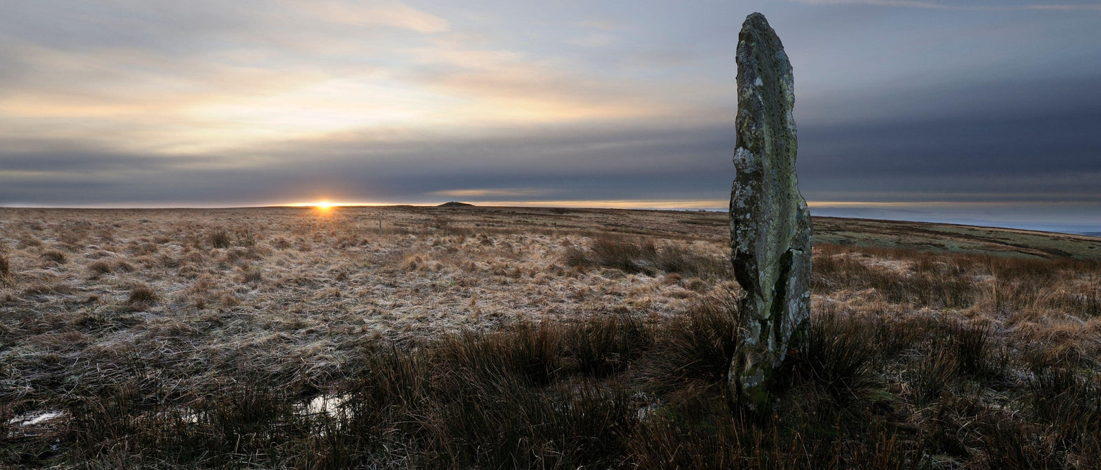
The tallest standing stone on Exmoor, the Challacombe Longstone was erected much later than most standing stones. Put up around 1500 BC, during the Bronze Age, it is about as removed in time from the great stones at Avebury as we are from the Middle Ages. You’ll also find a number of round barrows in the area, which implies that this area may have held major significance to the people of the time.
The Longstone lies in the middle of a windswept, often boggy moor. The walk can be difficult after wet weather, and you are likely to fall into bogs if you’re not careful. To get there, follow the B3358 east from Simonsbath. The road will take a sharp bend after three miles or so, and you’ll see a large layby when it does. Pull in here, at the entrance of YHA Pinkery (51.172166, -3.853644, grid ref SS705430, sat nav postcode EX35 6PZ), and follow the path north to Pinkery Pond. Next, take a left heading east for around a mile. It’s worth bringing a map and compass or a reliable phone app to avoid getting lost.

The Langdale axe factory, on the perilous scree slope of Pike of Stickle, was once home to the ancient craft of greenstone axe-making. In Neolithic times, axes were highly prized items, traded far and wide across ancient Britain and beyond. We have no real equivalent today, but they would have been as valued as a Swiss Rolex watch or a pair of handcrafted Italian shoes. Skilled axe-makers would have carved out their trade in this precarious workplace, open to the elements. They often made rough cuts of the axes before they were polished and set with wooden handles. Many of these rough cuts can still be found on the mountainside for those willing to spend the time looking!
It’s a stiff climb up to the axe factory, and you’ll need to be in good shape to do it. Park in the Langdales National Trust car park and follow the path west past Loft Crag. Continue on the ridge until you see the scree slope and cave to your left. The scree can be dangerous, and it’s an advantage to bring trekking poles to aid your balance. If you’re souvenir hunting, the stone axe rough cuts are sometimes found in the scree.

Like a crown of thorns, the unusual outward-leaning stones of Bryn Cader Faner set it apart from its contemporaries, making it arguably one of the most spectacular ancient monuments in the whole of Wales. This Bronze Age burial cairn has endured much over the last few thousand years and would have looked very different in the third millennium BC when it was erected. It’s thought that nineteenth-century treasure hunters stole the central cist (an ancient stone coffin where bones or ashes were kept, along with artefacts). Later, in the twentieth century, the British Army used it for target practice, blowing up or dislodging some of the stones.
Bryn Cader Faner is not the easiest site to reach, but the walk through the foothills of the rugged Rhinogydd mountains is accompanied by the echo of the whistle from the Ffestiniog & Welsh Highland steam railway. Take the minor road northeast from Talsarnau to Bryn Bwbach. From there, head east until you can’t drive any further, and park. Use a map and compass or navigation app to find the stone circle from this point – it’s reasonably straightforward, but the path can be hard to locate at times.

Another of North Wales’s most spectacular prehistoric sites, this impressive hillfort sits atop the peak of Yr Eifl, on the picturesque Llŷn Peninsula. It’s thought that as many as 400 people may have lived in this Iron Age settlement. The footings of most of the huts are remarkably well preserved, giving visitors a clear idea of what life might have been like all those years ago. Thought to have been built around 200 BC, the site continued to be used into the Roman occupation and may have been abandoned as late as 400 AD. To put that into perspective, this is the same span of time between the modern day and the reign of Henry VIII.
Follow the A499 southwest from Caernarfon until you reach the roundabout to Nefyn and the B4417. After passing through the village, you’ll see a pull-in and the hill of Tre’r Ceiri to your right. From here, it’s a straightforward but steep walk up Yr Eifl to reach the village.

With an opening the size of a cathedral window, Thor’s Cave is a majestic sight high above the Manifold Way. Carved out of limestone, the huge opening offers incredible views of the surrounding countryside. It’s likely that ancient hunting parties used the cave as shelter in much the same way modern wild campers might. Artefacts from almost every historical era have been found here, ranging from the Neolithic period (4500–2500 BC) through the Bronze Age (2500–500 BC), the Iron Age (500 BC–43 AD), and even to the Roman occupation.
Thor’s Cave became a popular tourist attraction during the Victorian era, when it had its own railway station, served by the Leek and Manifold Light Railway. Today the old railway line has been repurposed as a walking and cycling path called the Manifold Way. Follow the Manifold Way north from its starting point on the A523, east of Waterhouses (approximately 4.5 miles or 7 km). Alternatively, walk south from Hulme End (3.75 miles or 6 km) or west from Wetton (1 mile or 1.3 km) to reach the cave.

The largest of the two cairns (burial chambers) at Camster is 60m long, 20m wide, and over 5,000 years old. Visitors can crawl into the cairn, which opens into a chamber large enough to stand in, made of uprights and dry-stone walling. It’s staggering to think that a structure of this size and craftsmanship predates the earliest pyramids by at least 250 years.
A long road runs east from Lybster, off the A99, to the A882 near Watten village, close to Watten Loch. The cairns are 8km north of Lybster or just over 12km south of Watten. They are best visited as part of a bikepacking adventure. For those comfortable with wild camping, there are suitable spots near the cairns.

Castle Haven Dun is a little-known, ivy-covered Iron Age tower hidden in the corner of a farmer’s field. Duns or brochs were proto-castles, built around the time of the Roman occupation of Britain (which occurred only on a small scale in Scotland). Nobles of the day lived here with their families, often bringing cattle inside if rustlers or enemy tribes were spotted in the area. The site was rebuilt from near rubble in 1905 by Mr James Brown, the Laird of Knockbrex.
The cows in the field can be feisty, especially during calving season, so tread carefully. Take the cycle route (also driveable) south from Kirkcudbright on the B727. It will join a minor road at Bourge. After crossing the stone bridge over the burn, look for a small brook (barely a stream). The Dun is in the corner of the next field and may look like a pile of ivy until you get close.

The Rollright Stones refer to three ancient sites west of the village of Great Rollright, set in bucolic surroundings on the border of Oxfordshire and Warwickshire. The oldest of the three sites is the Whispering Knights, a collapsed dolmen or burial chamber dating back to the Neolithic. Then there is the King’s Men, a stone circle thought to resemble those in the Lake District, suggesting trade links between these distant monuments. Lastly, there is the lonely King Stone, marking the site of a Bronze Age burial ground.
Follow Banbury Road east from Chipping Norton, taking the first exit at the roundabout onto the A3400 for 2.5 miles. Turn left toward Little Rollright. After approximately half a mile, pull into the layby and follow the signs to the Stone Circle.
 |
 |