Your Cart is Empty
English


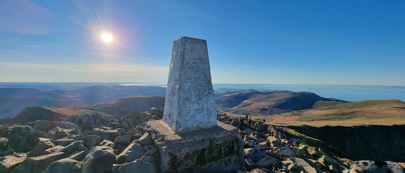
If you’ve spent much time walking in the British countryside, you’ll undoubtedly have seen one, touched one or perhaps even stood on top of one. We’re referring, of course, to the iconic trig pillar – the squat, truncated obelisks that are frequently found atop UK hills and mountains, but which crop up in all sorts of other strange places too, from coastal cliffs and farmers’ fields to military firing ranges and even back gardens. These curious landscape features tend to spark plenty of interest – and rightly so, for they have a fascinating history, dating back to the early twentieth century.

Today, thanks to modern technology, we have highly accurate mapping at our fingertips. But in the early 1930s, map making was still based on increasingly outdated 18th- and 19th-century data known as 'Principal Triangulation'. A more accurate and comprehensive system of observations was needed. So, in 1935, Ordnance Survey initiated an ambitious project that would become known as the 'Retriangulation of Great Britain'. Led by a Royal Engineers-trained army officer, Brigadier Martin Hotine, it would create a unified nationwide mapping projection: the basis of the metric national grid reference system and the 1:25,000 scale maps we use today.
The project relied on the mathematical process of triangulation, which determines the location of a geographical point by measuring angles to it from known points at either end of a fixed baseline. Measurements were taken using a telescope-like surveying instrument called a theodolite, which required a stable and perfectly level base. That's where triangulation pillars – or 'trig' pillars – came in. Mostly built to a standard design specified by Hotine himself, they provided a steady platform for accurate measuring, as well as a secure mounting point for the sensitive equipment.

Hotine could hardly have known how iconic his trig pillars would eventually become. His basic design consists of a flat-topped square concrete obelisk, tapering upwards. On top, you'll normally find a brass plate with three grooved arms and a central hole, originally used to mount the theodolite. A metal plaque or Ordnance Survey Bench Mark (with the initials OSBM) and a reference number is usually set into the pillar too. There are exceptions though – some pillars are built from local stone or slate, not concrete, while others are circular, not square. In Scotland there are even some taller, cylindrical pillars of a different design, known as 'Vanessas'.

Today, many trigs have taken on their own identities, being creatively remodelled by enterprising locals. Famously, there's a trig pillar painted as a little yellow Minion at Monk Bretton near Barnsley, and a grey alien at Hurlet Hill, Glasgow. Other common adornments include the English or Tudor rose (found, for example, atop Winter Hill in Lancashire) and the Welsh dragon (e.g at Hay Bluff in the Brecon Beacons).
Trig pillars are unique to Britain. Though various other countries also have networks of trigonometrical or triangulation stations – including the USA, Ireland, Australia, New Zealand, South Africa and Japan – none share the same distinctive design as our squat little obelisks.

Some walkers call these structures 'trig points', rather than trig pillars. This isn't incorrect, but it's worth noting that though all trig pillars are trig points, not all trig points are (or were) trig pillars. Confused? Well, sometimes, there was no need for a pillar to be constructed, since another landscape feature such as a church spire, chimney or lighthouse could be used for triangulation. These were generally just sighted from other trigs – you wouldn't want to set up a theodolite on top of them! In addition, there were many other types of triangulation point, including bolts, blocks, rivets, Berntsens, Fenomarks and Curry Stools. In total, these various points total around 25,000 locations.
In contrast, there were far fewer trig pillars – though still around 6,500 in total. Each was carefully positioned, marking a point with accurate eastings and northings coordinates. When the network was complete, each trig point was also intervisible – that is, it was possible in clear weather to see at least two other trig points from any one trig point (though this is not necessarily still the case today). In addition, most trig pillars had a flush bracket at the base of the pillar that specified their height above sea level.

The Retriangulation of Great Britain was a herculean endeavour that took nearly three decades to complete – the first pillar was positioned in 1936, the last in 1962. Their construction meant carrying heavy materials and equipment to remote sites, and labouring in difficult conditions. Some teams had to excavate as much as 15 feet underground to secure the pillars in place. The work of the surveyors was just as arduous, and even more meticulous – observations were made, checked and rechecked, often over a period of several days and even weeks. There was plenty of waiting around for clear, favourable conditions to use the theodolite. Surveyors' accounts of the task reveal that wet clothing, frozen fingers and bleary eyes were typically the order of the day (and night).

The results, though, were impressive. The project was a resounding success, paving the way for modern mapping. For the time, it was also astonishingly precise. In 2015, OS surveyors returned to the trig pillar on the summit of Ben Nevis to re-measure the mountain's height, though this time using advanced Global Navigation Satellite System (GNSS) positioning rather than theodolites and triangulation. Despite the increased accuracy of modern technology, it was found that the result obtained back in 1949 was only a few centimetres short of the peak's true height. The 2015 team measured it at exactly 1,344.527 metres – though this was rounded up to 1,345m, which meant it appeared as though the Ben had grown by a metre. The new tech did make the process much quicker though – the GPS-based calculation took a mere two hours. Back in 1949, it had taken a team of seven surveyors 20 nights to obtain their measurements.
Still, the negligible difference in the height of Britain's tallest mountain is testament to the dedication and meticulousness of all those involved in the original retriangulation project. And though trig pillars are no longer used for mapping, having long been superseded by GPS satellites and aerial photography, they remain useful and much-loved local landmarks – prominent sentinels of Britain's hills, mountains, coast and countryside.

A number of walkers have made it their mission to visit or 'bag' all 6,000+ remaining trig pillars in Britain. The first person to achieve this was Rob Woodall. Back in April 2016, Rob completed a 14-year-long personal quest to bag all of Britain's then extant trig pillars – some 6,190 in total. His final trig was at Benarty Hill in Fife – and fittingly, Ordnance Survey commemorated his achievement by presenting him with his very own OS Bench Mark at the summit. He cited his motivation for this epic feat as being down to a number of factors; namely, the diversity of different locations to visit, an interest in mapping, and the challenge of ticking off a really big list…
If those are the sort of things that inspire you to start bagging trigs too, various online resources might be useful – and much quicker than simply poring over hundreds of Ordnance Survey maps! Trigbagging.co.uk has an interactive map that can be used to discover trig points near you. If you start to find you can't walk past a trig pillar without bagging it, you might like to log your finds at trigpointing.uk. And lastly, for a comprehensive database of GPS waypoints that pinpoint all the trig pillars in the UK, visit haroldstreet.org.uk/trigpoints/